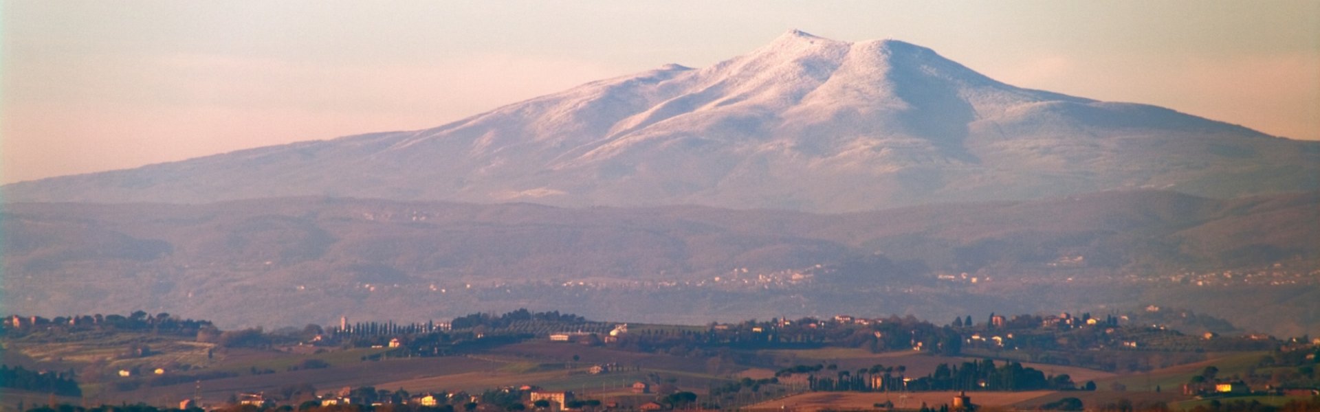
Skip to content
Itineraries
5 days in the shadow of the Monte Amiata volcano

A tour amidst the colours, flavours and traditions of the ancient Tuscan mountain

These days, no one thinks as the Etruscans did that the large mountain, with its unmistakable profile, rising from the Earth in the south of Tuscany, between the Provinces of Siena and Grosseto, is the home of Tinia, the equivalent of the Roman Jupiter. Yet still today, the inactive volcano exercises its vital influence for hundreds of kilometres around, just as it has done for thousands of years. Monte Amiata stands unmistakably with its austere and mysterious profile and can still be sensed everywhere: in the warm waters of the springs flowing from the heart of the earth, in the sour odour of the fumaroles that can still be smelt on the southern face of the mountain, in the extensive stretches of beech and chestnut trees that envelop the rocky volcanic cone, in the colours of the meadows that surround it, and in the fertile land that man has shaped to its will, harvesting wines, oils, cheeses and meats of the highest quality.

This alone would be inviting enough for a trip to the slopes of the Amiata, but that’s not all. Alongside the history of the volcano, as ancient as the meadow, is the history of man and the civilization that has arisen over the centuries, thriving and leaving behind traces over time. Merchants and pilgrims travelling along the via Francigena, Lombard princes in search of conquests that, entranced with wonder for the beauty of these places, fell in love and decided to build their homes right here, outlaws, the memory of whom still arouses fear and respect at the very mention of their name, traditions, and legends written about by Dante and Boccaccio, becoming key pieces of medieval literature: it’s history that can be experienced first-hand, in the stone villages of Amiata, with its towers, castles, fortresses, churches and abbeys.

This 5-day itinerary certainly can’t cover the vast wealth of Amiata’s nature and history, but it will definitely unveil the soul of the ancient volcano and make you discover the ancient civilization that lived in the shadow of its profile. The point of departure of each excursion must be reached by car.

1.
FIRST DAY
Bagni San Filippo: the volcano’s ancient springs

Ancient thermal baths, chestnut groves and medieval villages. This journey for discovering the Amiata begins in a small, ancient village, Bagni San Filippo, whose name evokes one of the precious gifts of the ancient volcano: hot water springs. The origins of the village, nestled on the slopes of the Amiata, goes back to Antiquity: a thermal bathing center even in the Roman era, it’s mentioned in medieval texts as early as the 12th century. At the end of the 1200s, Ristoro d'Arezzo described with wonder the calcareous formations of the Fosso Bianco, rocks shaped into fantastical forms by the volcano’s ancient waters and which today have odd names like “glacier” and “white whale”.

With a ring-shaped itinerary lasting about three hours, we can explore the town and these magnificent waters. The route begins at the Fosso, whose temperature allows for a restorative bath even in the off season. This area is a string of pools and tubs filled with turquoise waters surrounded by rocks covered in white calcium, including the one known as the Balena Bianca, or White Whale. The route continues to the Grotto of San Filippo, where according to tradition, in 1269, St. Philip Benizi took shelter here to pray, far from the Conclave in Viterbo, where they were trying to elect Clement IV’s successor, which Philip believed to be something contemptable. Continuing, the path weaves through the chestnut grove before reaching Palazzo di Pietrineri, from where it’s possible to deviate to the old mercury mine and the area with puzzolaie, from where the hot water and sulphurous vapours emerge. Returning to the Palazzo, you can reach the village of Campiglia d'Orcia via a small road, another small, ancient medieval gem with the Church of San Biagio and the ruins of the Castle of the Visconti and Salimbeni, destroyed by the Sienese in 1234.

7.2 km
schedule
Duration: 
1 day
Show on map
Show on map

Ancient thermal baths, chestnut groves and medieval villages. This journey for discovering the Amiata begins in a small, ancient village, Bagni San Filippo, whose name evokes one of the precious gifts of the ancient volcano: hot water springs. The origins of the village, nestled on the slopes of the Amiata, goes back to Antiquity: a thermal bathing center even in the Roman era, it’s mentioned in medieval texts as early as the 12th century. At the end of the 1200s, Ristoro d'Arezzo described with wonder the calcareous formations of the Fosso Bianco, rocks shaped into fantastical forms by the volcano’s ancient waters and which today have odd names like “glacier” and “white whale”.

With a ring-shaped itinerary lasting about three hours, we can explore the town and these magnificent waters. The route begins at the Fosso, whose temperature allows for a restorative bath even in the off season. This area is a string of pools and tubs filled with turquoise waters surrounded by rocks covered in white calcium, including the one known as the Balena Bianca, or White Whale. The route continues to the Grotto of San Filippo, where according to tradition, in 1269, St. Philip Benizi took shelter here to pray, far from the Conclave in Viterbo, where they were trying to elect Clement IV’s successor, which Philip believed to be something contemptable. Continuing, the path weaves through the chestnut grove before reaching Palazzo di Pietrineri, from where it’s possible to deviate to the old mercury mine and the area with puzzolaie, from where the hot water and sulphurous vapours emerge. Returning to the Palazzo, you can reach the village of Campiglia d'Orcia via a small road, another small, ancient medieval gem with the Church of San Biagio and the ruins of the Castle of the Visconti and Salimbeni, destroyed by the Sienese in 1234.

  • straighten
    Lunghezza tappa
    7.2 km
  • schedule
    Duration
    1 day
Show on map
Show on map
2.
second day
On the trails of outlaws and pilgrims: from Radicofani to Abbadia San Salvatore

His name is legend by now: Ghino di Tacco, the rebellious Sienese thief and nobleman – historians debate his aristocratic origins but nothing has yet to be made official – whose raids were feared by all – pilgrims and merchants – travelling along the via Francigena. The Sienese outlaw was perhaps the most famous ruler of the second stop on our journey, the medieval village of Radicofani. This is where he went to escape justice in Siena, taking possession of the fortress, which became the main quarters for him and his bodyguards and from where they would organize new raids. The Fortress is still there and is worth a visit, as is the village below, boasting stone houses with balconies decorated with flowers. Once you’ve seen the town and the fortress, follow the route on foot to Abbadia San Salvatore, along the historic stretch of the Francigena. Fortunately, you won’t run the same risks that Ghino di Tacco did when travelling this route: just a strong pair of legs and you’re good to go. The route begins at the 25 km marker on the Sarteano-Radicofani country road, and you’ll soon find yourself on one of the famous white roads all the way to Poggio l'Apparitoia. Along the way, you’ll also see the ruins of historic buildings beyond the Paglia creek in the town of Casette, which were rest stops and shelters for pilgrims. The itinerary continues under the Cassia viaduct and includes another small ford, this time the Pagliola creek. On the horizon, the town of Abbadia San Salvatore appears as it must have to medieval pilgrims.

9.8 km
schedule
Duration: 
1 day
Show on map
Show on map

His name is legend by now: Ghino di Tacco, the rebellious Sienese thief and nobleman – historians debate his aristocratic origins but nothing has yet to be made official – whose raids were feared by all – pilgrims and merchants – travelling along the via Francigena. The Sienese outlaw was perhaps the most famous ruler of the second stop on our journey, the medieval village of Radicofani. This is where he went to escape justice in Siena, taking possession of the fortress, which became the main quarters for him and his bodyguards and from where they would organize new raids. The Fortress is still there and is worth a visit, as is the village below, boasting stone houses with balconies decorated with flowers. Once you’ve seen the town and the fortress, follow the route on foot to Abbadia San Salvatore, along the historic stretch of the Francigena. Fortunately, you won’t run the same risks that Ghino di Tacco did when travelling this route: just a strong pair of legs and you’re good to go. The route begins at the 25 km marker on the Sarteano-Radicofani country road, and you’ll soon find yourself on one of the famous white roads all the way to Poggio l'Apparitoia. Along the way, you’ll also see the ruins of historic buildings beyond the Paglia creek in the town of Casette, which were rest stops and shelters for pilgrims. The itinerary continues under the Cassia viaduct and includes another small ford, this time the Pagliola creek. On the horizon, the town of Abbadia San Salvatore appears as it must have to medieval pilgrims.

  • straighten
    Lunghezza tappa
    9.8 km
  • schedule
    Duration
    1 day
Show on map
Show on map
3.
third day
At the summit of the Amiata

In Abbadia San Salvatore, an important and historic center located in a strategic position on the Via Francigena, you can still admire an atmosphere of the Middle Ages in the shadow of the ancient volcano. The abbey around which the village grew was founded by the Lombard nobleman Erfone with authorization from King Rachis in 742, partly because he wanted to establish a good relationship with the Church and partly because he wanted to control a route that was not only religious in nature but also fundamental for merchants. A walk through the village’s historic center allows us to experience the historic splendour of this place and the echo of Benedictine monks, who in the scriptorium copied the ancient codices that were handed down to them. It was here that for 1,000 years the oldest copy of the Vulgate was conserved, the Latin version of the Bible of St. Jerome. In addition to a stroll through the town center, a visit to the Mining Museum is worth a visit, which documents cinnabar mining for producing mercury, another feature of the Amiata. And while you’re here, head to the ancient volcano: Abbadia is actually the perfect starting point for climbing to its peak.  

The circular route lasts around 5 hours and can therefore be perfect for a morning hike, visiting the town in the afternoon. The route passes by the Cantore refuge, which can be reached via an evocative beech wood forest. The path then heads up to Prato delle Macinaie and follows (with white and red markers) the steep route of the winter ski runs before reaching the large monumental cross at 1,728 meters. The Amiata’s real peak is a little bit higher (1,738 meters). Between enormous boulders, you can see the statue of the Madonnina degli Scout, from where you can admire the most beautiful view in the whole of the Val d'Orcia, all the way to Siena. Turn around and you’ll see an endless horizon ranging from the Lake of Bolsena to the silhouette of the Terminillo. Heading down the ski runs, you’ll return to the Cantore refuge and, walking back the way you came, you’ll come across the Amiatino refuge. Upon returning to Abbadia and before exploring the town, fill up with a slice of Ricciolina. Orange-flavoured marzipan filling and shavings of shortcrust pastry on top: these are the ingredients. Just a bite and you’ll discover how delicious it is.

7.2 km
schedule
Duration: 
1 day
Show on map
Show on map

In Abbadia San Salvatore, an important and historic center located in a strategic position on the Via Francigena, you can still admire an atmosphere of the Middle Ages in the shadow of the ancient volcano. The abbey around which the village grew was founded by the Lombard nobleman Erfone with authorization from King Rachis in 742, partly because he wanted to establish a good relationship with the Church and partly because he wanted to control a route that was not only religious in nature but also fundamental for merchants. A walk through the village’s historic center allows us to experience the historic splendour of this place and the echo of Benedictine monks, who in the scriptorium copied the ancient codices that were handed down to them. It was here that for 1,000 years the oldest copy of the Vulgate was conserved, the Latin version of the Bible of St. Jerome. In addition to a stroll through the town center, a visit to the Mining Museum is worth a visit, which documents cinnabar mining for producing mercury, another feature of the Amiata. And while you’re here, head to the ancient volcano: Abbadia is actually the perfect starting point for climbing to its peak.  

The circular route lasts around 5 hours and can therefore be perfect for a morning hike, visiting the town in the afternoon. The route passes by the Cantore refuge, which can be reached via an evocative beech wood forest. The path then heads up to Prato delle Macinaie and follows (with white and red markers) the steep route of the winter ski runs before reaching the large monumental cross at 1,728 meters. The Amiata’s real peak is a little bit higher (1,738 meters). Between enormous boulders, you can see the statue of the Madonnina degli Scout, from where you can admire the most beautiful view in the whole of the Val d'Orcia, all the way to Siena. Turn around and you’ll see an endless horizon ranging from the Lake of Bolsena to the silhouette of the Terminillo. Heading down the ski runs, you’ll return to the Cantore refuge and, walking back the way you came, you’ll come across the Amiatino refuge. Upon returning to Abbadia and before exploring the town, fill up with a slice of Ricciolina. Orange-flavoured marzipan filling and shavings of shortcrust pastry on top: these are the ingredients. Just a bite and you’ll discover how delicious it is.

  • straighten
    Lunghezza tappa
    7.2 km
  • schedule
    Duration
    1 day
Show on map
Show on map
4.
fourth day
From Piancastagnaio to Pigelleto: the civility of the forests

Leaving Abbadia behind, we now head south. Piancastagnaio’s a name is a clear indication of what we can expect: a small, medieval town on a plateau immersed in chestnut forests, an oasis of total peace with medieval buildings: the Aldobrandesco Castle, which protected the village from the danger of enemy raids, along with the medieval defense walls, and the Church of San Francesco, which envelopes us in a 14th-century atmosphere. Further to the south, another medieval village awaits us at the foot of Monte Civitella: Castell'Azzara. The Aldobrandeschi’s power also extended to this town, even if, should the version narrated by Dante in Purgatory be believed, this was thanks to a stroke of luck, since an important member of the family, Bonifacio, had the courage and good fortune to win the town in a game of dice. In the town, the Church of the Madonnna del Rosario conserves important frescoes and paintings from the 16th and 17th centuries, while just outside the town is the Villa Sforzesca, dating to 1580. From this village dotted with medieval stone houses, we head even further south, surrounded by the smells and colours of nature in the Pigelleto Nature Reserve. The reserve can be visited by following a circular route, with red and white markers, which takes about 3 hours. Changing between unpaved paths and trails through the forest, you’ll be immersed in lush nature, with interesting posters along the way that illustrate the wealth of plant and animal life in the park, the umpteenth feature of the ancient volcano: beach, chestnut, maple and oak trees greet you on your walk and vistas open up, offering views of the Amiata and the villages of Piancastagnaio and Radicofani.

5.1 km
schedule
Duration: 
1 day
Show on map
Show on map

Leaving Abbadia behind, we now head south. Piancastagnaio’s a name is a clear indication of what we can expect: a small, medieval town on a plateau immersed in chestnut forests, an oasis of total peace with medieval buildings: the Aldobrandesco Castle, which protected the village from the danger of enemy raids, along with the medieval defense walls, and the Church of San Francesco, which envelopes us in a 14th-century atmosphere. Further to the south, another medieval village awaits us at the foot of Monte Civitella: Castell'Azzara. The Aldobrandeschi’s power also extended to this town, even if, should the version narrated by Dante in Purgatory be believed, this was thanks to a stroke of luck, since an important member of the family, Bonifacio, had the courage and good fortune to win the town in a game of dice. In the town, the Church of the Madonnna del Rosario conserves important frescoes and paintings from the 16th and 17th centuries, while just outside the town is the Villa Sforzesca, dating to 1580. From this village dotted with medieval stone houses, we head even further south, surrounded by the smells and colours of nature in the Pigelleto Nature Reserve. The reserve can be visited by following a circular route, with red and white markers, which takes about 3 hours. Changing between unpaved paths and trails through the forest, you’ll be immersed in lush nature, with interesting posters along the way that illustrate the wealth of plant and animal life in the park, the umpteenth feature of the ancient volcano: beach, chestnut, maple and oak trees greet you on your walk and vistas open up, offering views of the Amiata and the villages of Piancastagnaio and Radicofani.

  • straighten
    Lunghezza tappa
    5.1 km
  • schedule
    Duration
    1 day
Show on map
Show on map
5.
fifth day
Santa Fiora and Arcidosso: flavours, colours and traditions of the Amiata

With the smells and colours of the Pigelleto Reserve still imprinted in your mind, head to the north, where you’ll come across one of the Amiata’s most spectacular villages. Santa Fiora, an orange flag village and member of the Most Beautiful Villages in Italy club, it’s nestled on the slopes of the ancient volcano, welcoming us from afar with a view of its red roofs clustered together, hiding a maze of medieval streets. The town is ideal for taking a slow, peaceful stroll, beginning in the piazza, the historic center of the village and bordered by medieval walls, with the Clock Tower and Palazzo Sforza, before following via Carolina, with its typical three-doored medieval houses, and via del Fondaccio, with the Parish Church of Santa Flora e Lucilla, home to 15th-century terracottas from the workshop of Andrea Della Robbia. Further on is the village’s terziere, with the ancient Via Lunga and the Church of San Michele Arcangelo, which was once part of an Augustinian monastic complex. Beyond San Michele is a small paradise of tranquillity: the peschiera, a basin of water burrowed between the medieval buildings and the forest that collects waters from the Fiora and which was used by the Aldobrandeschi as a hatchery for trout. 

It will be hard to leave Santa Fiora behind, but the Amiata has other villages that await. And so, after tasting Acquacotta (a typical soup made in Santa Fiora with wild radish), continue north until you see the unmistakable silhouette of the tower of the Aldobrandeschi castle in Arcidosso, protecting the town and warning of enemies – of which there many between the 1200s and 1500s – ensuring that anyone with bad intentions would not succeed so easily in their mission. 

The town welcomes visitors with its ancient terzieri: the first is where the Castle is located, home also to the Teatro degli Unanimi, the oldest theatre in the Grosseto region, dating to 1741, and the Church of San Niccolò, the oldest church in the town, built in the 12th century and conserving a 16th-century wooden crucifix; the second is the Codaccio terziere, where the home of Lazaretti, founder of the Giurisdavidismo religious movement, and the Church of San Leonardo can be found; and finally, the Sant'Andrea terziere, with Porta Talassese, on which the historic coat of arms of the Republic of Siena can still be seen. The Church of the Madonna Incoronata was built in 1348 as gratitude for the end of the plague.

Arcidosso also boasts the Monte Amiata chestnut IGP, celebrated every October with events, concerts and sagre, a kind of street party with food, as well as guided visits to the surrounding chestnut groves and with rivers of artisanal beers, another speciality of this town. Speaking of specialities, we can’t forget Arcidosso’s soup, a mix of local products, made from stale bread, fresh onions, tomatoes, ricotta, spinach and extra-virgin olive oil, meant to be eaten on toasted bread with scallions.

schedule
Duration: 
1 day
Show on map
Show on map

With the smells and colours of the Pigelleto Reserve still imprinted in your mind, head to the north, where you’ll come across one of the Amiata’s most spectacular villages. Santa Fiora, an orange flag village and member of the Most Beautiful Villages in Italy club, it’s nestled on the slopes of the ancient volcano, welcoming us from afar with a view of its red roofs clustered together, hiding a maze of medieval streets. The town is ideal for taking a slow, peaceful stroll, beginning in the piazza, the historic center of the village and bordered by medieval walls, with the Clock Tower and Palazzo Sforza, before following via Carolina, with its typical three-doored medieval houses, and via del Fondaccio, with the Parish Church of Santa Flora e Lucilla, home to 15th-century terracottas from the workshop of Andrea Della Robbia. Further on is the village’s terziere, with the ancient Via Lunga and the Church of San Michele Arcangelo, which was once part of an Augustinian monastic complex. Beyond San Michele is a small paradise of tranquillity: the peschiera, a basin of water burrowed between the medieval buildings and the forest that collects waters from the Fiora and which was used by the Aldobrandeschi as a hatchery for trout. 

It will be hard to leave Santa Fiora behind, but the Amiata has other villages that await. And so, after tasting Acquacotta (a typical soup made in Santa Fiora with wild radish), continue north until you see the unmistakable silhouette of the tower of the Aldobrandeschi castle in Arcidosso, protecting the town and warning of enemies – of which there many between the 1200s and 1500s – ensuring that anyone with bad intentions would not succeed so easily in their mission. 

The town welcomes visitors with its ancient terzieri: the first is where the Castle is located, home also to the Teatro degli Unanimi, the oldest theatre in the Grosseto region, dating to 1741, and the Church of San Niccolò, the oldest church in the town, built in the 12th century and conserving a 16th-century wooden crucifix; the second is the Codaccio terziere, where the home of Lazaretti, founder of the Giurisdavidismo religious movement, and the Church of San Leonardo can be found; and finally, the Sant'Andrea terziere, with Porta Talassese, on which the historic coat of arms of the Republic of Siena can still be seen. The Church of the Madonna Incoronata was built in 1348 as gratitude for the end of the plague.

Arcidosso also boasts the Monte Amiata chestnut IGP, celebrated every October with events, concerts and sagre, a kind of street party with food, as well as guided visits to the surrounding chestnut groves and with rivers of artisanal beers, another speciality of this town. Speaking of specialities, we can’t forget Arcidosso’s soup, a mix of local products, made from stale bread, fresh onions, tomatoes, ricotta, spinach and extra-virgin olive oil, meant to be eaten on toasted bread with scallions.

  • schedule
    Duration
    1 day
Show on map
Show on map

Explore

Discover something of interest near this itinerary