Grand Tour of Maremma

Grand Tour of Maremma: an itinerant journey by bicycle that encloses, as in a casket, nature, history, culture, traditions, food and wine of the Maremma Grossetana. Departure and arrival of this trip is the city of Grosseto, however, since it is a ring route, each cycle traveler can choose the starting point from an intermediate point of the itinerary, also in relation to their place of origin. The Grand Tour itinerary is marked throughout its development on the territory by special tourist signs with classic white characters on a brown background, bearing the name of the next town and the logo of the ‘Cicloturismo in Maremma’ project.
In each of the daily routes into which the itinerary is divided, we reach places symbolic for the history of the Maremma and beyond; this is the case, for example, of the stops that head to Massa Marittima, Campagnatico and Santa Fiora, three medieval villages among the most beautiful in Italy, linked to characters mentioned by Dante Alighieri in the Divine Comedy.
In Ribolla, we pass through one of the Gates of the Metalliferous Hills Technological and Archaeological Park, a project that aims to recover - for educational and cultural purposes - buildings, shafts and whatever else was used for the extraction and processing of metals. The history of the Maremma is inextricably linked to that of the Ribolla lignite mines: active until the 1950s, they were closed on May 4, 1954, due to a fire that killed 43 miners. The tragic story was taken up in 1962 by Grosseto writer Luciano Bianciardi in his book La vita agra. The novel inspired the film of the same name starring Ugo Tognazzi by director Carlo Lizzani.
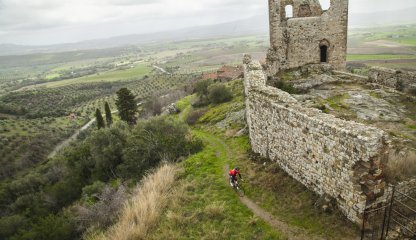
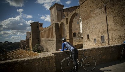
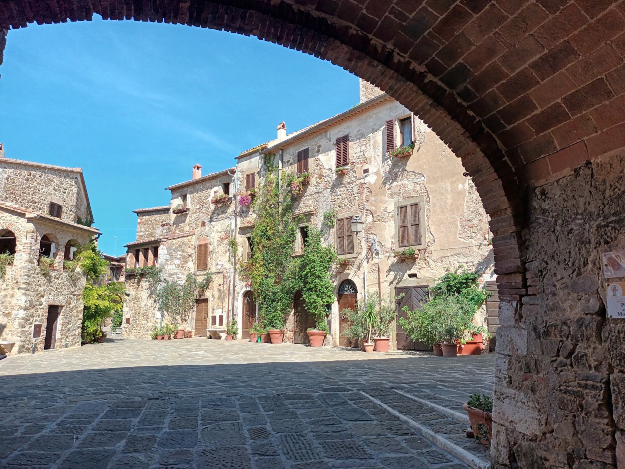
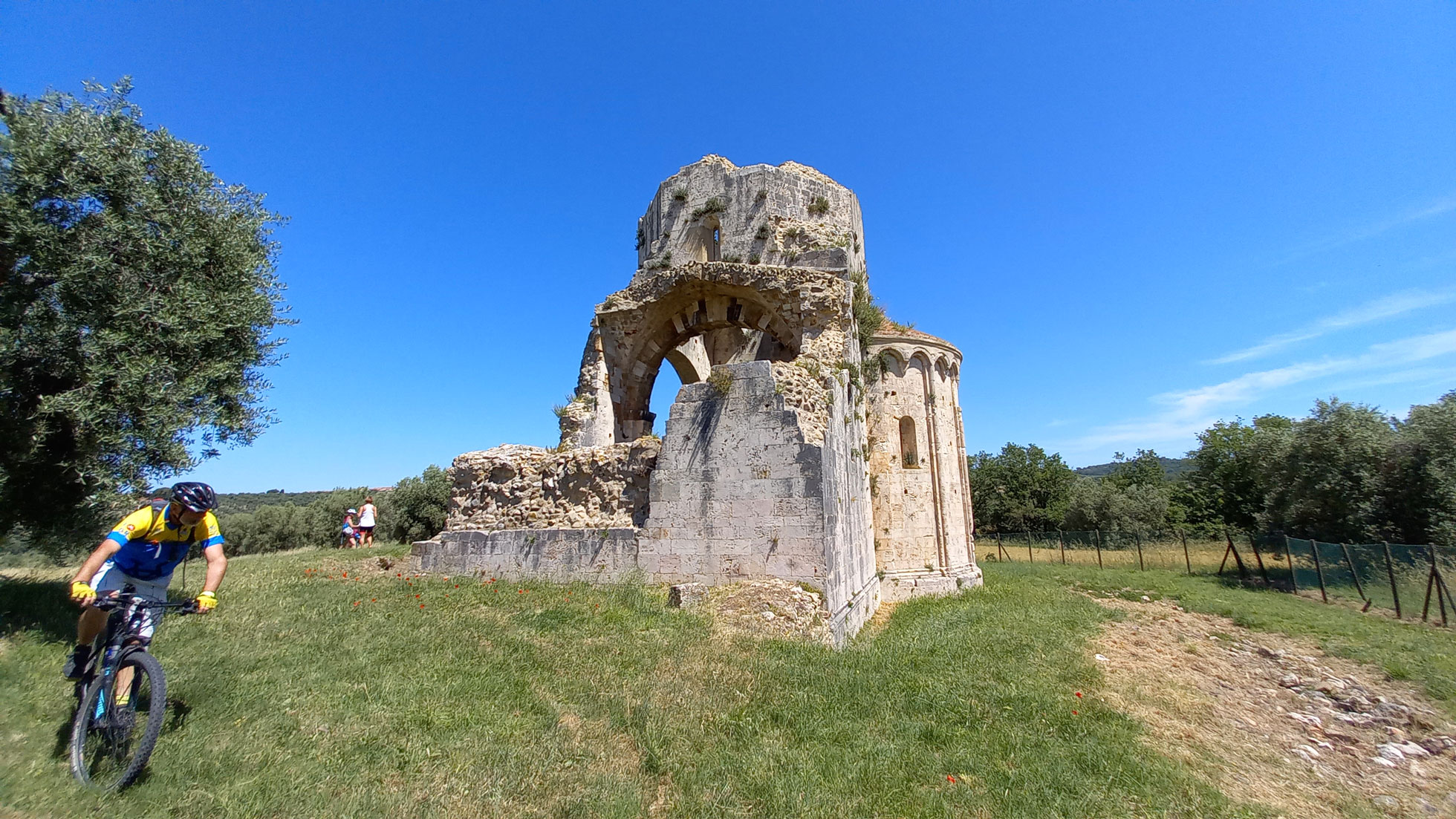
Of ancient stories and deeds of cunning condottieri the Maremma is certainly not stingy; we find evidence of them among the sunburnt stones, the scorching August sun, of the villages we encounter in the stages of our Maremma journey such as Roccatederighi, Roccastrada, Paganico, Cinigiano, Arcidosso. In Sorano and Pitigliano, here are the enigmatic Etruscan monumental tombs, the Via Cave, the Orsini fortress, the Ghetto and the oldest aqueduct in Maremma. The vapors of the sulfurous waters of nearby Saturnia bring back memories of atmospheres from Dante's circles as we climb the hairpin bends leading to Manciano, the medieval village known as "the spy of the Maremma" for its geographical position, overlooking the Orbetello lagoon and the Maremma plains between Tuscany and Lazio. Awe and wonder are aroused in us by the majestic remains of the San Bruzio Abbey, which stand centuries old in the countryside of Magliano in Toscana, another splendid example of a medieval walled town, where legends of possessed witches dancing, around thousand-year-old olive groves, on full moon nights are still told. The itinerary divided into six stages, as presented here, can be considered within the reach of anyone with a minimum of familiarity with a road bike (the e-bike obviously makes everything even more accessible). Of course, nothing prohibits an enthusiast with more training from merging the stages and completing the ring in three to four days.
From Grosseto train station, we begin pedaling toward the sea of Grosseto's beaches, along a bicycle/pedestrian path that takes us near Marina di Grosseto. In the shadow of the Tombolo pine forest, we pedal along the frieze of SP 158 to Castiglione della Pescaia. Past the canal bridge, we follow the Grilli marker. We head inland, skirting the Diaccia Botrona Nature Reserve, which to this day represents what remains of the ancient Lake Prile. The walls of the Arce, which rise on the hill of Vetulonia, see us pass through on the provincial road of Strette below, before joining the former Aurelia state road (SP152) at Grilli. Markers for La Pesta lead us to the shores of Accesa Lake. We resume pedaling uphill following the Capanne trail marker, a former mining village that preserves the director's villa and the workers' dwellings. Placed on the fork at the entrance to the place, we find the Massa Marittima marker, the medieval gem of the Maremma. Near Piazza Garibaldi is BikeGarage&More, an area dedicated to refreshments and e-bike recharging.
From Grosseto train station, we begin pedaling toward the sea of Grosseto's beaches, along a bicycle/pedestrian path that takes us near Marina di Grosseto. In the shadow of the Tombolo pine forest, we pedal along the frieze of SP 158 to Castiglione della Pescaia. Past the canal bridge, we follow the Grilli marker. We head inland, skirting the Diaccia Botrona Nature Reserve, which to this day represents what remains of the ancient Lake Prile. The walls of the Arce, which rise on the hill of Vetulonia, see us pass through on the provincial road of Strette below, before joining the former Aurelia state road (SP152) at Grilli. Markers for La Pesta lead us to the shores of Accesa Lake. We resume pedaling uphill following the Capanne trail marker, a former mining village that preserves the director's villa and the workers' dwellings. Placed on the fork at the entrance to the place, we find the Massa Marittima marker, the medieval gem of the Maremma. Near Piazza Garibaldi is BikeGarage&More, an area dedicated to refreshments and e-bike recharging.
- straighten
Length77 Km
-
Physical engagementMedium
-
Technical difficultyEasy
- trending_down
Descent764 m
- trending_up
Ascent401 m
- vertical_align_top
Maximum altitude425 m
From Massa Marittima take SP 162 in the direction of Siena. After passing Ghirlanda, the last stop of the old Follonica - Massa mining railroad, at Pian di Mucini we turn left and then follow the signs for Niccioleta. We pedal slightly uphill for about 6 km, finding SP 162 again near Prata. We now follow the GT sign "Tatti", which we will reach from SP 54 Cerro Balestro, a beautiful road that winds slightly uphill through cork and holm oak forests. From the ancient castle of Tatti, the track bends left (Roccatederighi marker). You pass through Sassofortino and pedal on SP 8 reaching Roccastrada. Continue downhill on SP 157 for about 5 km to an obvious right turn where you take SP 46 Tollero following the GT signs indicating Paganico. The current coplanar road to E78 accompanies us to the junction with SP 18 for the turn-off at Campagnatico, ancient castle of the Aldobrandeschi family of Sovana, mentioned by Dante in the 11th canto of Purgatory.
From Massa Marittima take SP 162 in the direction of Siena. After passing Ghirlanda, the last stop of the old Follonica - Massa mining railroad, at Pian di Mucini we turn left and then follow the signs for Niccioleta. We pedal slightly uphill for about 6 km, finding SP 162 again near Prata. We now follow the GT sign "Tatti", which we will reach from SP 54 Cerro Balestro, a beautiful road that winds slightly uphill through cork and holm oak forests. From the ancient castle of Tatti, the track bends left (Roccatederighi marker). You pass through Sassofortino and pedal on SP 8 reaching Roccastrada. Continue downhill on SP 157 for about 5 km to an obvious right turn where you take SP 46 Tollero following the GT signs indicating Paganico. The current coplanar road to E78 accompanies us to the junction with SP 18 for the turn-off at Campagnatico, ancient castle of the Aldobrandeschi family of Sovana, mentioned by Dante in the 11th canto of Purgatory.
- straighten
Length68 Km
-
Physical engagementMedium
-
Technical difficultyEasy
- trending_down
Descent1040 m
- trending_up
Ascent1180 m
- vertical_align_top
Maximum altitude611 m
From the center of Campagnatico we return to SP 18 towards the Ombrone Valley, which we cross at Pianetti. At the next junction with SP 17 Voltina, we follow the GT "Granaione" marker. We continue for about 4 km on the flat, and then start pedaling uphill towards Cinigiano. The route towards Monte Amiata continues, pedaling steadily uphill towards Monticello Amiata and Arcidosso, one of the most evocative and characteristic villages of the Amiata due to the presence of the Aldobrandesca Fortress, which towers imposingly at the top of the village. We follow the signs to Santa Fiora, where we will also find the possibility of recharging our e-bikes, thanks to a public station near the Infopoint in Piazza Garibaldi. Of definite interest is a visit to the Monte Amiata Mercury Mines Museum. Not to be missed and a walk through the alleys of the historic center to the beautiful Peschiera Park.
From the center of Campagnatico we return to SP 18 towards the Ombrone Valley, which we cross at Pianetti. At the next junction with SP 17 Voltina, we follow the GT "Granaione" marker. We continue for about 4 km on the flat, and then start pedaling uphill towards Cinigiano. The route towards Monte Amiata continues, pedaling steadily uphill towards Monticello Amiata and Arcidosso, one of the most evocative and characteristic villages of the Amiata due to the presence of the Aldobrandesca Fortress, which towers imposingly at the top of the village. We follow the signs to Santa Fiora, where we will also find the possibility of recharging our e-bikes, thanks to a public station near the Infopoint in Piazza Garibaldi. Of definite interest is a visit to the Monte Amiata Mercury Mines Museum. Not to be missed and a walk through the alleys of the historic center to the beautiful Peschiera Park.
- straighten
Length51 Km
-
Physical engagementMedium
-
Technical difficultyEasy
- trending_down
Descent1168 m
- trending_up
Ascent740 m
- vertical_align_top
Maximum altitude831 m
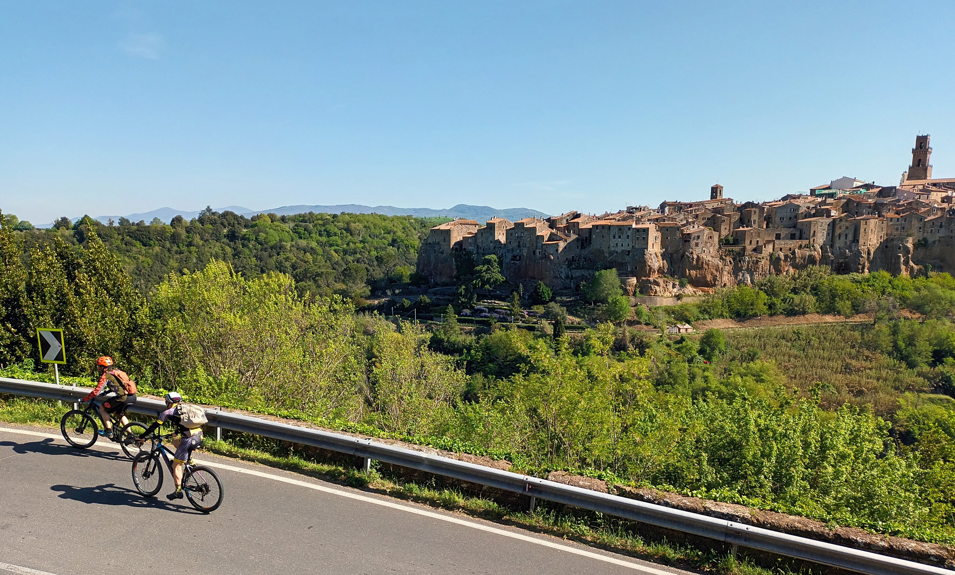
From the historic center of Santa Fiora, we follow the "Selva" marker, taking the SP Pitigliano - Santa Fiora. Fast hairpin bends accompany us on the sloping ground stretch adjacent to the Fiora River, and then we face the climb that leads to the hamlet of Selva and the Convent of the Holy Trinity, a pleasant place rich in history and legends. Next, we reach Selvena and the remains of the Silvana Fortress from the Aldobrandesque period. Evident traces of the mining activity that marked this area, which began in ancient times and lasted until the 1970s. The "Elmo" marker, near the Selvena cemetery, heralds our entry into an area where geology, history and landscape seem to compete to offer us new and exciting experiences. We have reached the gates of the City of Tuff, which sees in the villages of Sorano and Pitigliano the highest architectural expression of this extensive geographical area on the border between Tuscany and Lazio. Near San Quirico di Sorano is the rock town of Vitozza. Enter Pitigliano, at Madonna delle Grazie, with a spectacular view of the tuff spur on which the town stands.
From the historic center of Santa Fiora, we follow the "Selva" marker, taking the SP Pitigliano - Santa Fiora. Fast hairpin bends accompany us on the sloping ground stretch adjacent to the Fiora River, and then we face the climb that leads to the hamlet of Selva and the Convent of the Holy Trinity, a pleasant place rich in history and legends. Next, we reach Selvena and the remains of the Silvana Fortress from the Aldobrandesque period. Evident traces of the mining activity that marked this area, which began in ancient times and lasted until the 1970s. The "Elmo" marker, near the Selvena cemetery, heralds our entry into an area where geology, history and landscape seem to compete to offer us new and exciting experiences. We have reached the gates of the City of Tuff, which sees in the villages of Sorano and Pitigliano the highest architectural expression of this extensive geographical area on the border between Tuscany and Lazio. Near San Quirico di Sorano is the rock town of Vitozza. Enter Pitigliano, at Madonna delle Grazie, with a spectacular view of the tuff spur on which the town stands.
- straighten
Length52 Km
-
Physical engagementMedium
-
Technical difficultyEasy
- trending_down
Descent810 m
- trending_up
Ascent1232 m
- vertical_align_top
Maximum altitude838 m
Pitigliano and Manciano, two villages separated by the deep valley carved by the waters of the Fiora River that splits the tuff plateau in two, where ancient peoples have left signs of their passage. Tuff remains, again, the defining element of the area, and in some places the asphalt ribbon of SR 74 Maremmana enters the trench, opening a gap in the tuff formation. The bridge over the Fiora River marks the point of change of gradient for us; from now on we climb in a series of meandering curves that accompany us to the Aldobrandesca Fortress of Manciano. Known as "the spy of the Maremma" because of its geographical location, the fortress dominates the Maremma plains and coastline between Tuscany and Lazio. We pedal at ease, on the fast curves drawn on the hills by SP 159 (marker Scansano) that descend to Montemerano. Past the small farming village of Pomonte, we leave SP 159 for SP 146 Aquilaia (marker Magliano in Toscana near the junction) to reach Magliano from the Colle di Lupo consortium road. Scenic effect guaranteed for the long avenues lined with cypress trees that we find near the farm of the same name.
Pitigliano and Manciano, two villages separated by the deep valley carved by the waters of the Fiora River that splits the tuff plateau in two, where ancient peoples have left signs of their passage. Tuff remains, again, the defining element of the area, and in some places the asphalt ribbon of SR 74 Maremmana enters the trench, opening a gap in the tuff formation. The bridge over the Fiora River marks the point of change of gradient for us; from now on we climb in a series of meandering curves that accompany us to the Aldobrandesca Fortress of Manciano. Known as "the spy of the Maremma" because of its geographical location, the fortress dominates the Maremma plains and coastline between Tuscany and Lazio. We pedal at ease, on the fast curves drawn on the hills by SP 159 (marker Scansano) that descend to Montemerano. Past the small farming village of Pomonte, we leave SP 159 for SP 146 Aquilaia (marker Magliano in Toscana near the junction) to reach Magliano from the Colle di Lupo consortium road. Scenic effect guaranteed for the long avenues lined with cypress trees that we find near the farm of the same name.
- straighten
Length51 Km
-
Physical engagementMedium
-
Technical difficultyEasy
- trending_down
Descent775 m
- trending_up
Ascent857 m
- vertical_align_top
Maximum altitude430 m
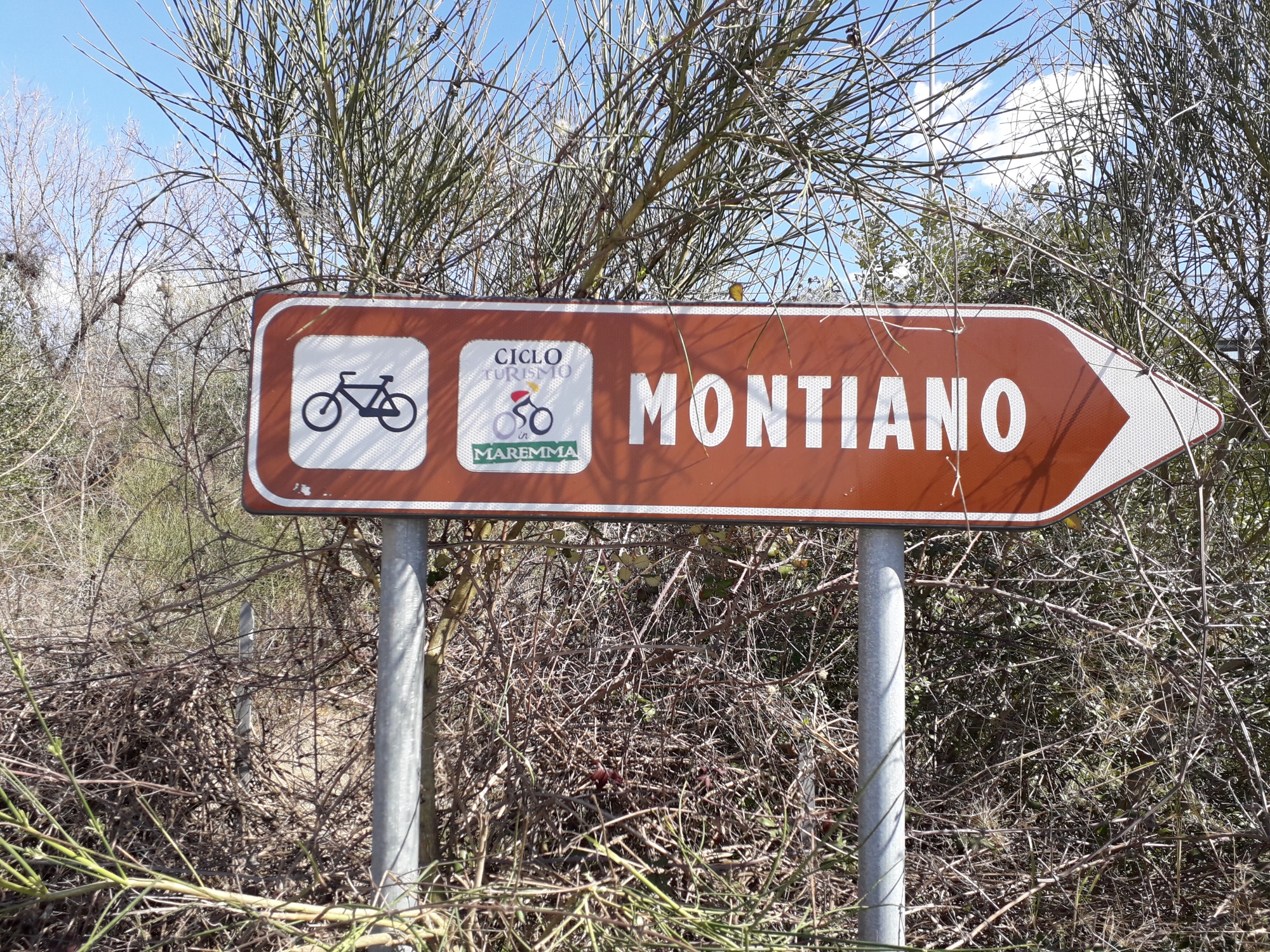
We leave Magliano by climbing the hills in the direction of Scansano. Let's be surprised by the medieval tower that soars 29 m from the top of the ancient village of Pereta; it is the only and the highest one left intact of the many watchtowers that existed in Maremma. In Scansano, a walk through the "inside", the old part of the village, is not to be missed. Continue uphill on SP 159, which crosses the village, (marker "Montiano" in front of the municipal building) climbs near the sports field and continues in the direction of Grosseto until the intersection with SP 9 "Aione" (marker Montiano). Wide views of the islands of the Tuscan archipelago open up before us on this long descent that takes us from the hills to the Grosseto plain. Near Montiano, a visit to the village strongly recommended, the itinerary continues toward Grosseto on the SP 16. Just before the junction of the provincial road with the SS1 Aurelia, we take the Grancia municipal road, following the "Grosseto" sign. After crossing the bridge over the Ombrone River on SP 154, we enter the city, aiming for the train station, the end point of the itinerary.
We leave Magliano by climbing the hills in the direction of Scansano. Let's be surprised by the medieval tower that soars 29 m from the top of the ancient village of Pereta; it is the only and the highest one left intact of the many watchtowers that existed in Maremma. In Scansano, a walk through the "inside", the old part of the village, is not to be missed. Continue uphill on SP 159, which crosses the village, (marker "Montiano" in front of the municipal building) climbs near the sports field and continues in the direction of Grosseto until the intersection with SP 9 "Aione" (marker Montiano). Wide views of the islands of the Tuscan archipelago open up before us on this long descent that takes us from the hills to the Grosseto plain. Near Montiano, a visit to the village strongly recommended, the itinerary continues toward Grosseto on the SP 16. Just before the junction of the provincial road with the SS1 Aurelia, we take the Grancia municipal road, following the "Grosseto" sign. After crossing the bridge over the Ombrone River on SP 154, we enter the city, aiming for the train station, the end point of the itinerary.
- straighten
Length54 Km
-
Physical engagementMedium
-
Technical difficultyEasy
- trending_down
Descent805 m
- trending_up
Ascent952 m
- vertical_align_top
Maximum altitude559