The Sea Route


After a bath of culture in the city that was the cradle of the Renaissance, it can feel like taking a real bath, in a transparent sea and surrounded by nature. Nothing better, then, than to strap on a bicycle and, in three days, arrive in Piombino to embark for Elba Island. Don't take it as a trivial transfer, however. The itinerary develops on minor roads and dirt roads and is designed to savor some of the most beautiful territories of Tuscany: the Chianti, the Sienese, the Val di Merse, the Val di Cornia, the Maremma. An itinerary to be savored slowly while enjoying the wonderful Tuscan landscape. And "savoring" can be understood not only as a metaphor. In fact, crossing Tuscany also means crossing its flavors, its typical dishes and its wines. The route has been divided into five stages: three to cross the region and two to make the circumnavigation of Elba Island. A well-trained cyclist can make it even in three or two stages, but if you want to take the time to taste a glass of Chianti in Castellina, tour the walls of Monteriggioni or visit the Etruscan excavations of Populonia, we recommend following the scanning of the stages as prepared, to dilute the altimetry and mileage. However, the stages are fairly challenging and should not be taken lightly, all around 60 km and 1,000 meters of daily elevation gain; if you are not a regular cyclist, the use of an e-bike might be the most suitable means to enjoy the trip in absolute relaxation.
The La Via del Mare (Sea Route) route was kindly provided by Ediciclo Editore and is taken from the volume Pedala Italia (Ediciclo, 2020).
We set off heading south until we reach and pass Impruneta. We then continue toward Mercatale in Val di Pesa, facing the first challenging climb of the day. We continue on a splendid ridge trail, between the valleys of the Pesa and Greve, until we reach Panzano in Chianti, the ideal stopping point of the day. Remaining on the Via Chiantigiana, we lose altitude to climb up the opposite side and reach Castellina in Chianti, at the end of the last, challenging climb. The most is done; all that remains is to descend to Castellina scalo and use the last of our energy for the short final climb that brings us to the center of the village, the end of the stage, accompanied by Dante's words, "sulla cerchia tonda/Monteriggion di torri si corona" (on its circular parapets/Montereggione crowns itself with towers).
We set off heading south until we reach and pass Impruneta. We then continue toward Mercatale in Val di Pesa, facing the first challenging climb of the day. We continue on a splendid ridge trail, between the valleys of the Pesa and Greve, until we reach Panzano in Chianti, the ideal stopping point of the day. Remaining on the Via Chiantigiana, we lose altitude to climb up the opposite side and reach Castellina in Chianti, at the end of the last, challenging climb. The most is done; all that remains is to descend to Castellina scalo and use the last of our energy for the short final climb that brings us to the center of the village, the end of the stage, accompanied by Dante's words, "sulla cerchia tonda/Monteriggion di torri si corona" (on its circular parapets/Montereggione crowns itself with towers).
- straighten
Length64.8 Km
-
Physical engagementChallenging
-
Technical difficultyMedium
- trending_down
Descent1020 m
- trending_up
Ascent1210 m
- vertical_align_top
Maximum altitude580 m
We set out leaving Monteriggioni to descend toward the Elsa plain. A few kilometers and here we are at Abbadia Isola, the abbey where Sigeric of Canterbury stayed, the bishop who in 990 went from Canterbury to Rome (and back) keeping a punctual travel diary that has made it possible today to reconstruct accurately the route of the Via Francigena.
We continue past Strove until we join SP 541 where we turn left, crossing the Elsa on the Santa Giulia bridge. The road climbs a ridge that leads us, in a beautiful panoramic situation, to Casole d'Elsa, an ideal place for a snack. The route continues to offer splendid views as far as Monteguidi, which we reach by a route that in cycling jargon would be called eat and drink.
We now descend to cross the Cecina stream and climb up the other side to the gates of Montecastelli, a hamlet that we can visit with a detour to the right of about one kilometer, (also adding 80m of elevation gain). The route continues at altitude for about eight kilometers until we arrive at the foot of the last climb; three kilometers around 6.5 percent that will earn us the right to an excellent dinner in the village of Castelnuovo di Val di Cecina, this day's destination.
- straighten
Length52.1 Km
-
Physical engagementMedium
-
Technical difficultyMedium
- trending_down
Descent640 m
- trending_up
Ascent960 m
- vertical_align_top
Maximum altitude568 m
We are in the heart of the Metalliferous Hills, the territory of the "boric acid soffioni", puffs of steam that come out of the subsoil harnessed since the early 1900s to obtain geo-thermal energy. We set off south, surrounded by greenery, following SR 439 to the fork on the right for Monterotondo Marittimo, a charming highland village and an ideal place to stop for a coffee break. Just beyond the village, at the height of a small "majesty", we take the Montebamboli alley road on the left, beginning a long dirt stretch of about 12 km in the valley of the Milia and the ancient mines of Montebamboli.
Back on the asphalt road we take a right, climbing slightly up to Poggio al Cinghiale, where we will be able for the first time to catch a glimpse of the sea. From here begins a long descent that takes us to the Cornia valley floor where, at the junction with the SP19, we will turn right to reach the delightful village of Suvereto, topped by the Aldobrandesque fortress.
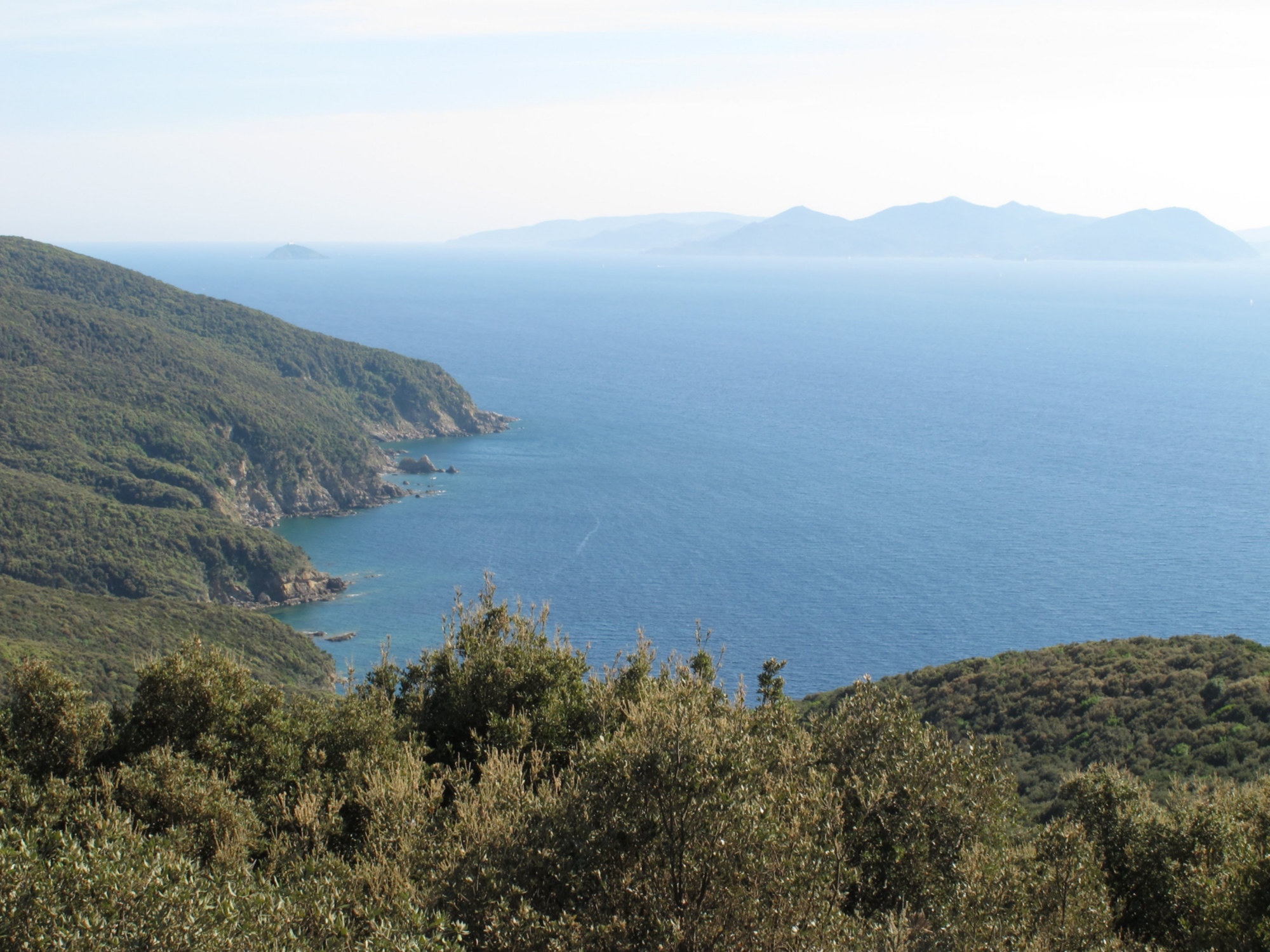
The road continues through the plains heading toward Venturina Terme and then to the Gulf of Baratti. We skim the Gulf and it becomes difficult to repel the urge to take our first swim in the Tyrrhenian Sea (and if you have a bathing suit with you, why not?). Here begins the last climb that will first take us to Populonia, the small and charming fortified village of Etruscan origin (a visit to the archaeological park and museum is recommended) and then cross the promontory of Piombino along a beautiful and wild dirt stretch, with splendid views of the sea and the islands of the Tuscan archipelago. The last, beautiful effort before descending to Piombino and taking the ferry to the Elba Island.
We are in the heart of the Metalliferous Hills, the territory of the "boric acid soffioni", puffs of steam that come out of the subsoil harnessed since the early 1900s to obtain geo-thermal energy. We set off south, surrounded by greenery, following SR 439 to the fork on the right for Monterotondo Marittimo, a charming highland village and an ideal place to stop for a coffee break. Just beyond the village, at the height of a small "majesty", we take the Montebamboli alley road on the left, beginning a long dirt stretch of about 12 km in the valley of the Milia and the ancient mines of Montebamboli.
Back on the asphalt road we take a right, climbing slightly up to Poggio al Cinghiale, where we will be able for the first time to catch a glimpse of the sea. From here begins a long descent that takes us to the Cornia valley floor where, at the junction with the SP19, we will turn right to reach the delightful village of Suvereto, topped by the Aldobrandesque fortress.
The road continues through the plains heading toward Venturina Terme and then to the Gulf of Baratti. We skim the Gulf and it becomes difficult to repel the urge to take our first swim in the Tyrrhenian Sea (and if you have a bathing suit with you, why not?). Here begins the last climb that will first take us to Populonia, the small and charming fortified village of Etruscan origin (a visit to the archaeological park and museum is recommended) and then cross the promontory of Piombino along a beautiful and wild dirt stretch, with splendid views of the sea and the islands of the Tuscan archipelago. The last, beautiful effort before descending to Piombino and taking the ferry to the Elba Island.
- straighten
Length72 Km
-
Physical engagementMedium
-
Technical difficultyMedium
- trending_down
Descent1420 m
- trending_up
Ascent890 m
- vertical_align_top
Maximum altitude680 m
After disembarking in Portoferraio we can begin our circumnavigation of the island, which has been divided into two stages to be done counterclockwise in order to have the sea always on our right. In this first stage we will go around the island to the west, circumnavigating Mount Capanne.
We set off heading towards Capo d'Enfola, a few kilometers from the port, but before descending towards the isthmus of the promontory (if we want to reach it we need to make a round trip because the road does not continue) we take a left along the steep via Acquaviva that becomes a small natural-bottomed road and allows us to reach Procchio, avoiding a long stretch of provincial road. The first two kilometers are challenging, with average gradient around 9 percent, then we begin to descend until we merge onto SP 24 and, taking a right, quickly reach Procchio and its beautiful beach.
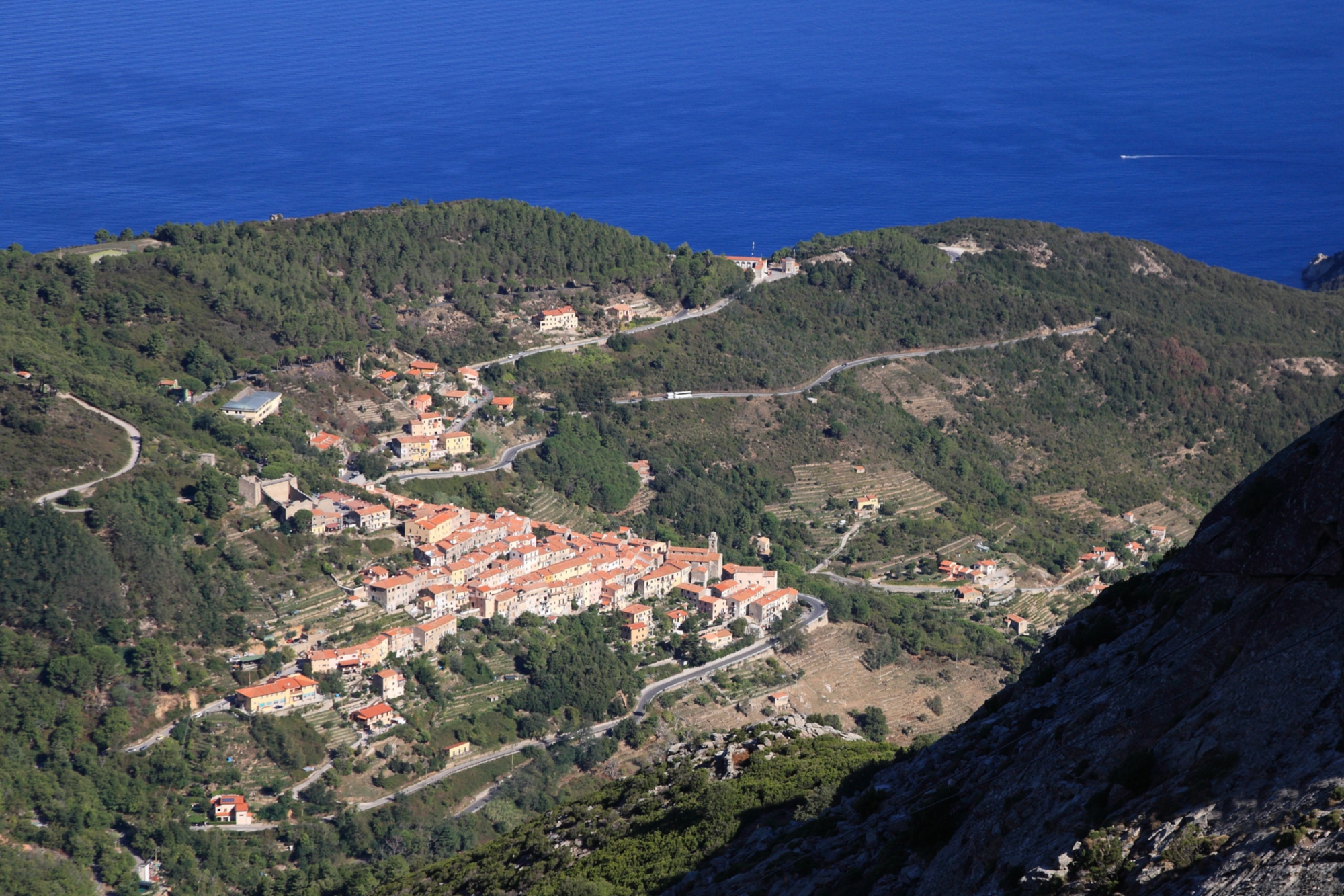
Continue for a few kilometers on the coastal road, with splendid views of the sea, until you reach Marciana Marina, a suitable stopping point to refresh and regain some strength before tackling the longest climb of the day. The road climbs for 5 km until reaching the 325 mbsl of Poggio and then the 370 mbsl of Marciana, two beautiful mountain villages with sea views. Once Marciana is reached, the most is done; the SP25, the obligatory road to complete the circumnavigation of the island, descends again skirting the sea, first remaining high on the coast and then approaching the water, giving the possibility of taking a bath at the beaches of Chiessi or Pomonte or in the enchanting one of Fetovaia, just before reaching our destination, Marina di Campo.
After disembarking in Portoferraio we can begin our circumnavigation of the island, which has been divided into two stages to be done counterclockwise in order to have the sea always on our right. In this first stage we will go around the island to the west, circumnavigating Mount Capanne.
We set off heading towards Capo d'Enfola, a few kilometers from the port, but before descending towards the isthmus of the promontory (if we want to reach it we need to make a round trip because the road does not continue) we take a left along the steep via Acquaviva that becomes a small natural-bottomed road and allows us to reach Procchio, avoiding a long stretch of provincial road. The first two kilometers are challenging, with average gradient around 9 percent, then we begin to descend until we merge onto SP 24 and, taking a right, quickly reach Procchio and its beautiful beach.
Continue for a few kilometers on the coastal road, with splendid views of the sea, until you reach Marciana Marina, a suitable stopping point to refresh and regain some strength before tackling the longest climb of the day. The road climbs for 5 km until reaching the 325 mbsl of Poggio and then the 370 mbsl of Marciana, two beautiful mountain villages with sea views. Once Marciana is reached, the most is done; the SP25, the obligatory road to complete the circumnavigation of the island, descends again skirting the sea, first remaining high on the coast and then approaching the water, giving the possibility of taking a bath at the beaches of Chiessi or Pomonte or in the enchanting one of Fetovaia, just before reaching our destination, Marina di Campo.
- straighten
Length56 Km
-
Physical engagementChallenging
-
Technical difficultyMedium
- trending_down
Descent1000 m
- trending_up
Ascent1040 m
- vertical_align_top
Maximum altitude374
We immediately set off uphill to climb over the mountain ridge that divides us from Lacona; three kilometers with a constant gradient to overcome a 250m difference in altitude. Having reached Lacona and returned to sea level, the route continues without any real climbs until Porto Azzurro, which we will reach in about ten kilometers, first following SP 30 and then SP 26, taking a right at the fork.
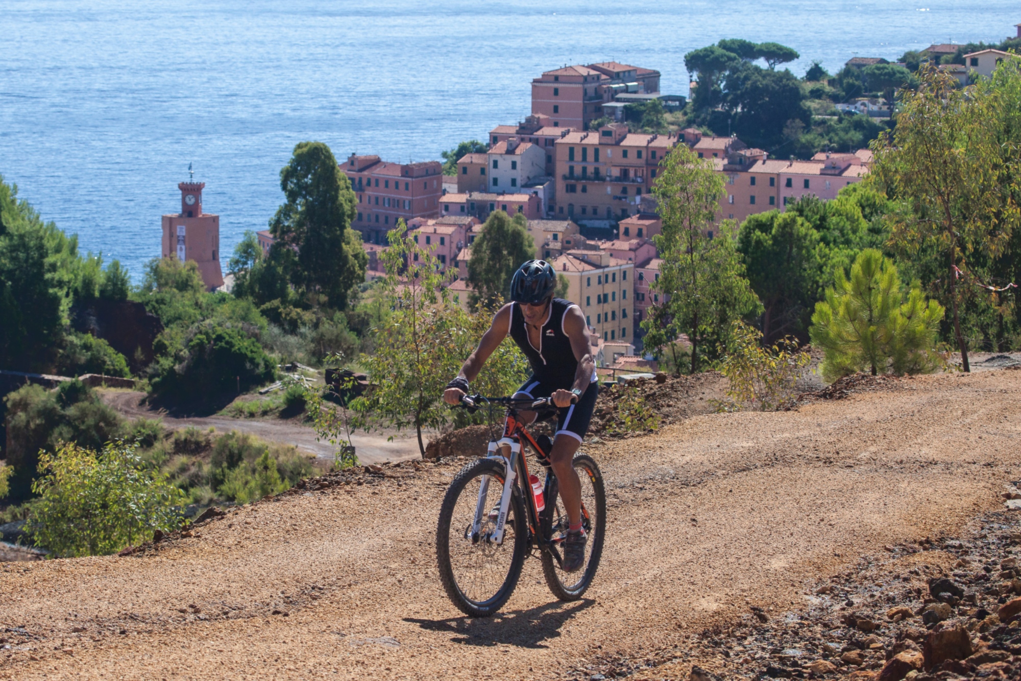
After a well-deserved coffee break, we begin our exploration of the Mount Serra cape along the beautiful Parata scenic road. We head toward Rio nell'Elba but, at the last traffic circle, aim instead for Rio Marina and then continue along the coast to Cavo.
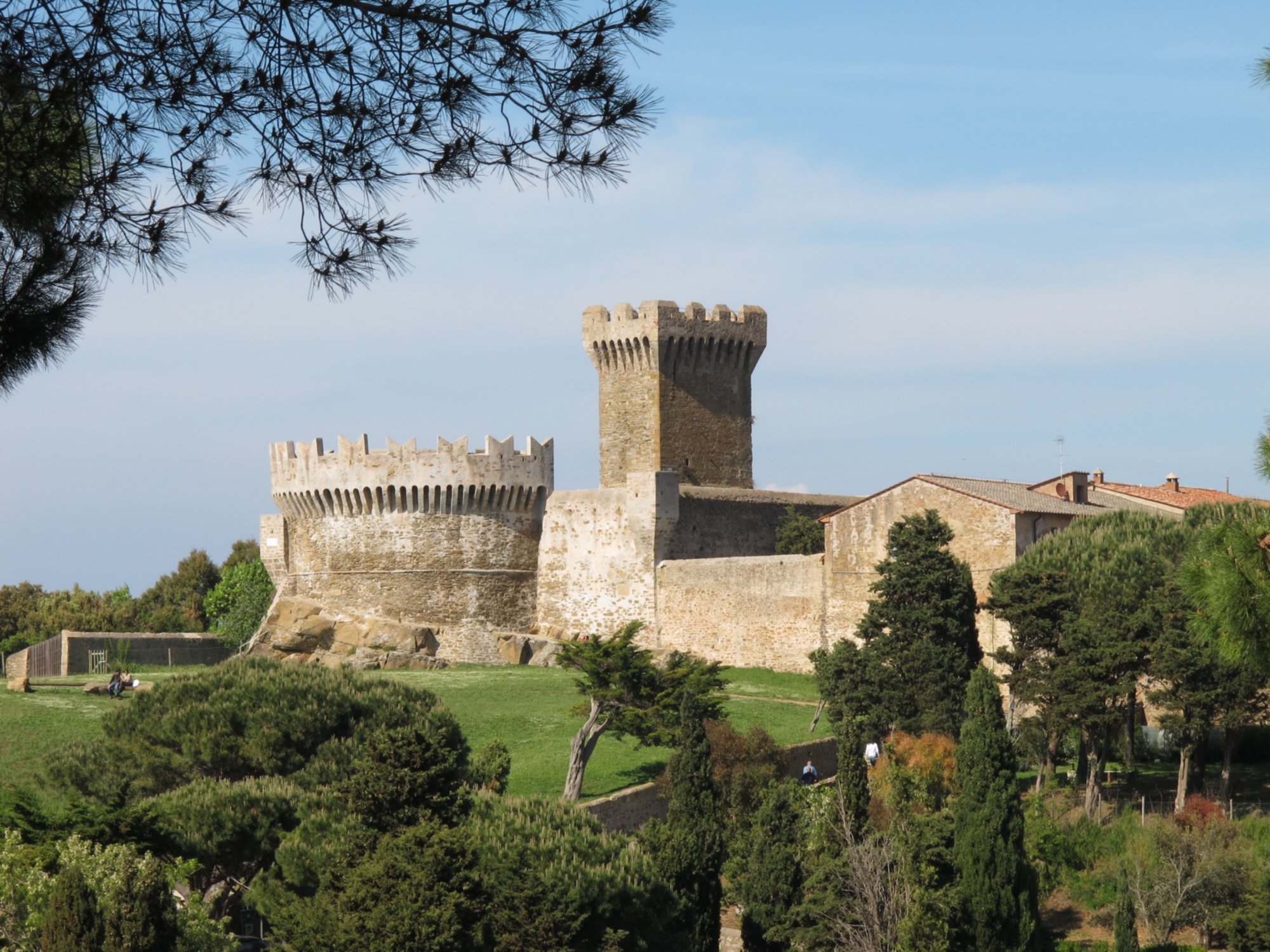
The road climbs smoothly to take us, this time yes, to Rio nell'Elba, where we begin the last, challenging climb: 3 kilometers with an average gradient around 8%, leading us to the Volterraio Pass and Volterraio Castle, the place where the Elbans sought escape from Saracen raids. The route ends with a steep descent to the sea and the last few kilometers on the flat that take us back to the ferry in Portoferraio.
We immediately set off uphill to climb over the mountain ridge that divides us from Lacona; three kilometers with a constant gradient to overcome a 250m difference in altitude. Having reached Lacona and returned to sea level, the route continues without any real climbs until Porto Azzurro, which we will reach in about ten kilometers, first following SP 30 and then SP 26, taking a right at the fork.
After a well-deserved coffee break, we begin our exploration of the Mount Serra cape along the beautiful Parata scenic road. We head toward Rio nell'Elba but, at the last traffic circle, aim instead for Rio Marina and then continue along the coast to Cavo.
The road climbs smoothly to take us, this time yes, to Rio nell'Elba, where we begin the last, challenging climb: 3 kilometers with an average gradient around 8%, leading us to the Volterraio Pass and Volterraio Castle, the place where the Elbans sought escape from Saracen raids. The route ends with a steep descent to the sea and the last few kilometers on the flat that take us back to the ferry in Portoferraio.
- straighten
Length63 Km
-
Physical engagementChallenging
-
Technical difficultyMedium
- trending_down
Descent1030
- trending_up
Ascent1150
- vertical_align_top
Maximum altitude330