


A slow journey through medieval villages and forests, taking you to gushing springs
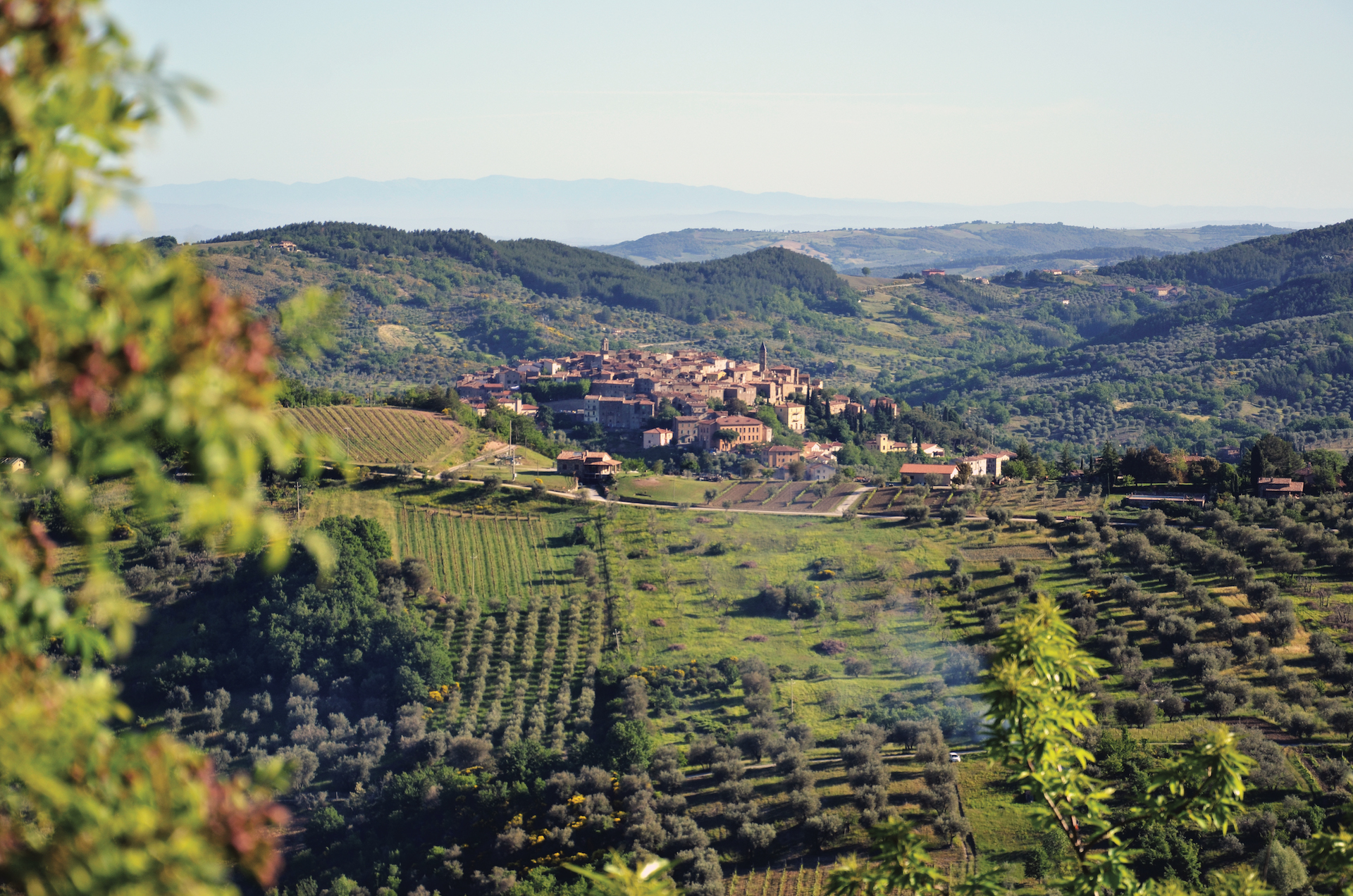
The unspoilt nature of Monte Amiata combined with the extraordinary power of the waters and its ancient villages: these are the elements that characterize the uniqueness of "Le Vie dell'Acqua", the water routes that stretch between the municipalities of Arcidosso, Castel del Piano, Santa Fiora, Seggiano and Castiglione d'Orcia.
Ten routes including a large circular trail of about 62 kilometers, to be covered on foot. A slow journey through medieval villages, centuries-old chestnut groves, silver fir tree woods and the splendid Monte Amiata Beech Forest, taking you to gushing springs.
A slow and sustainable tourism experience dedicated to nature lovers, all year round.
Two routes that come together to create a medium-difficulty itinerary about 10 km long, for exploring the waters of the picturesque village of Santa Fiora.
The first route starts from Piazza Garibaldi, the heart of Santa Fiora, and winds through the narrow streets of the historic center, between what remains of the ancient walls and the Parish Church of Sante Flora e Lucilla with its fine Della Robbia pottery, until it reaches the captivating Peschiera fish pond and the tunnels of the Fiora Springs, returning back along the of the Percorso dei Mulini nature trail.
Then there is the Church of San Rocco, which is the starting point for the second part of the route that leads you to the Terraio reservoir in Marroneto.
- straighten
Length10.3 Km
-
DifficultyAverage
- trending_down
Descent349 m
- trending_up
Ascent349 m
A circular route of about 7 km that passes through small villages and ancient mills until it reaches the legendary Acqua d'Alto waterfall in the municipality of Arcidosso.
From the Porta dell'Orologio (Gate of the Clock), in the heart of Arcidosso, you will reach the small village of Fornaci, once important for brick production. Along the way, you will encounter historical locations, like the birthplace of David Lazzaretti, the prophet of Monte Amiata, or the ruins of the "Mulinaccio", until you reach the Fonte dell'Acqua Bona spring that, according to legend, is linked to the figure of Pia de' Tolomei. Then there is the village of Canali and the Terra Gialla factory, where the Sienna pigment used to be produced.
Final destination is the striking 25-meter-high Acqua d’Alto Waterfall, located in a beautiful natural setting.
- straighten
Length6.6 Km
-
DifficultyAverage
- trending_down
Descent220 m
- trending_up
Ascent220 m
Another loop itinerary, with breathtaking views, natural springs and ancient stone buildings: the Burlana spring loop runs along a 5-kilometer route and touches the municipalities of Castel del Piano and Seggiano.
Departure is from the car park of the village of Tepolini: along a path with alternating uphill and downhill sections, it reaches the "Burlana” spring, a reserve full of life and biodiversity, surrounded by greenery.
Continuing on, you can admire centuries-old chestnut trees and ancient drying houses, where the chestnut growers of Monte Amiata once put the prized Amiata chestnuts to dry, and you will also reach the villages of Pian di Ballo and Leccio
- straighten
Length5.1 km
-
DifficultyAverage
- trending_down
Descent250 m
- trending_up
Ascent250 m
This is probably the most challenging itinerary of the Vie dell'Acqua water route: about 7.5 kilometers connecting the village of Collevergari to the Arbure and Bugnano Springs, just outside Castel del Piano. A short stretch of the route follows the path to the Monte Amiata Ring.
The route runs along a part of the mountain that is as yet quite unknown, among beautiful chestnut groves tended to like gardens and ancient lava rock flows that have watched over travelers’ footsteps of for thousands of years. Stony paths and old mule tracks bring to mind a past that is still alive, while looking out at the views along the way leaves you breathless.
- straighten
Length7.5 km
-
DifficultyDemanding
- trending_down
Descent430 m
- trending_up
Ascent430 m
A walk of about 10 kilometers in the magnificent Vivo Park, starting from the village of Vivo d'Orcia or from the car park along the road leading to Seggiano.
The route runs through chestnut woods and reaches the beautiful Amiata Beech Forest, allowing you to walk along the "Gorina" water channels, taking you to the Capovetra Spring.
- straighten
Length9.6 km
-
DifficultyAverage
- trending_down
Descent484 m
- trending_up
Ascent484 m
This 13-kilometer route connects the Ermicciolo Spring, in Vivo d'Orcia, to the Mining Museum in Abbadia San Salvatore.
It is a route characterized by technical sections and breathtaking panoramic viewpoints.
Beech and chestnut forests are the settings framing this trail from the very first steps you take.
- straighten
Length13,2 km
- trending_down
Descent481 mt
- trending_up
Ascent362 mt
This is the route that connects the 2 most important villages of Monte Amiata on the Siena side of the mountain.
Departure is from the Mineral Museum Park in Abbadia, which is of considerable historical and cultural importance, continuing on to the Laghetto Verde (Green Pond) and the Acqua Gialla Reservoir.
After a series of uphill and downhill stretches surrounded by the nature of Monte Amiata, you will come to Piancastagnaio.
- straighten
Length7,3 km
- trending_down
Descent203 mt
- trending_up
Ascent135 mt
The trail runs through the unspoiled nature of Monte Amiata.
Chestnut trees, silver fir tree woods and old mountain dwellings are the setting for this high-altitude circular route.
This route is about 14 kilometers long and it starts and ends near the enchanting Sanctuary of Madonna di San Pietro, in the outskirts of the town of Piancastagnaio.
- straighten
Length14 km
- trending_down
Descent319 mt
- trending_up
Ascent319 mt
The flowing of the water is the natural sound that accompanies the walkers who embark on this water route.
With its 19 kilometers, it is one of the longest trails marked out within this project to date and it allows you to discover numerous natural treasures, including the majestic Bugnano and Capovetra Springs.
- straighten
Length19,2 km
- trending_down
Descent726 mt
- trending_up
Ascent726 mt
This is a 62-kilometer loop trail to be covered on foot and completed in several stages.
The Great Ring brings together almost all the points of interest found along the 9 Vie dell’Acqua water route and often overlaps with the older, better-known Monte Amiata Ring.
Planning the route also means looking for accommodation in the villages crossed by this extensive itinerary.
- straighten
Length62,3 km
- trending_down
Descent2056
- trending_up
Ascent2056